The Drive Into Old Bay St. Louis by Pat Murphy - Historian and well-known coast musician Pat Murphy has been working on his memoir "Growing Up Downtown" for several years. During 2015, the Cleaver will feature one of his essays each month - along with historical photographs from his archives.
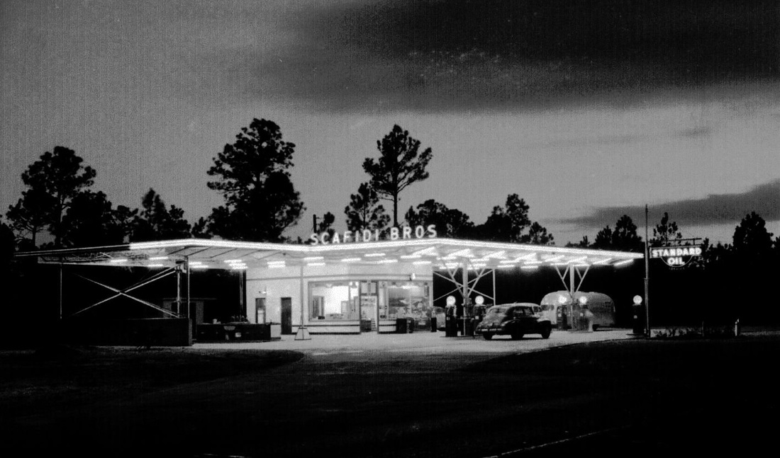
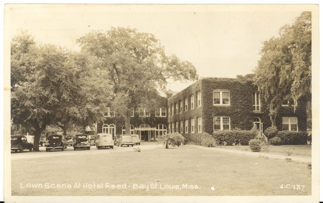
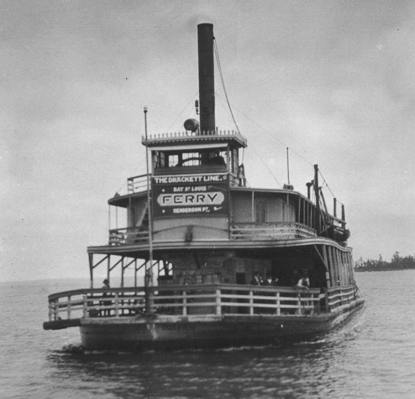
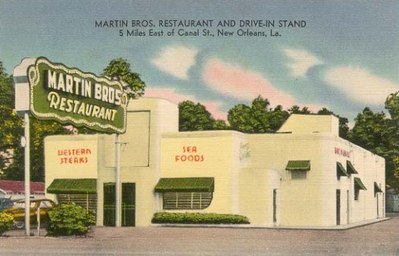 The drive on old Highway 90 both to and from the city of New Orleans is burned into my brain. Not only did my grandfather’s business deal with countless suppliers and businesses in the city, but because my mother’s family was from New Orleans, a lot of time was spent driving back and forth. I equate this old drive to a part in the Bay St. Louis experience of my youth. The Highway 90 journey when leaving New Orleans would usually begin on North Broad Avene with a turn onto Gentilly Boulevard, not far from Dillard University. Gentilly Boulevard wound through Gentilly and out to the Industrial Canal where it became known as Chef Menteur Highway. I can vividly remember the scent of roasting coffee when driving across the Industrial Canal. There was a huge coffee plant on the industrial canal just after crossing the bridge on the left. Martin Brothers Restaurant was located on the right just after going over the bridge and passing the coffee plant. Martin Brothers was a family favorite, literally a fine dining restaurant, a sandwich counter and drive-in all rolled into one. Martin Brothers was the home of the absolute best New Orleans poboy sandwiches that I’ve ever eaten. I’ve been eating poboys for sixty plus years and nobody’s poboys have ever been better - maybe close, but not better. My dad used to love to sit at the sandwich counter (Martin Brothers also had several large separate dining rooms) and watch the sandwich chef create his magic. He was an old Frenchman with a chef’s hat and wielding a very large butcher knife. He’d be back there spinning around making poboys and waving his arms telling the waitresses “watch the knife, watch the knife!” It was quite an experience to see and a show that my old man loved to watch. After driving out of New Orleans, Highway 90 continued to wind eastward through a lot of junkyards, boatyards and marine-type businesses until you came to Powers Junction. At this intersection, Highway 11 forked off of Chef Menteur Highway and ran north towards the Lake Pontchartrain bridge to Slidell and on to Hattiesburg and beyond. Powers’ Junction was a truck stop and restaurant, and was usually the breakfast stop for us when driving in from the east going to New Orleans. Martin Brothers was the place to eat for us when heading east out of New Orleans on the way home. 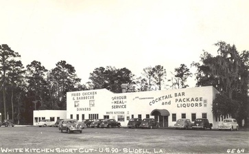 A few miles further east driving down Highway 90 was the Chef Menteur bridge. The Chef and the Rigolets are the two waterways that fill and drain massive Lake Pontchartrain. Once you crossed the Chef it was a winding, curvy, treacherous drive of about fifteen miles through the Lake Catherine – Lake Borgne area. There were hundreds of old, rustic weekend retreats and fishing camps with names like “Pop’s Hideaway," “Uncle Willie’s Retreat," “Daddy’s Dog House” and the like along this part of the highway. This winding stretch of the highway was particularly dangerous at night and especially in the fog. On the other end of this area at the approach to the Rigolets Bridge is the spot where Hollywood actress Jane Mansfield was killed in an automobile accident late one night on her way back to New Orleans after performing at Gus Stevens’ nightclub in Biloxi. The car that Mansfield was riding in rear-ended a semi truck that was stopped for a mosquito fogging truck. Both the Chef and the Rigolets bridges were old 1930s WPA-era concrete two-lane affairs. The Chef was a fairly short bridge but the Rigolets bridge was about three quarters of a mile, straight but very narrow. Both passes were very deep with swirling tidal currents either filling or draining Lake Pontchartrain. This bridge at The Rigolets was a scary experience to me as a youngster and if the drawbridge happened to get stuck open (which happened pretty frequently), you had to back off of the bridge and go all the way around through Slidell. Riding over this bridge in a school bus (like on high school football trips with the St. Stanislaus band) was really a scary experience because you were up high and looking down over the railing. Once you crossed over the Rigolets bridge, it was pretty much smooth sailing on into Mississippi with nothing of note except the intersection of Highway 190 which turned north towards Slidell and Baton Rouge (I remember the sign reading Baton Rouge 102 miles). At this junction was another legendary truck stop-restaurant and road house, the White Kitchen. This place also had great home cooked food and was our usual alternate stop for food on the way back from New Orleans. The Reptile Jungle Snake and Alligator Farm was right next door. There was another White Kitchen in Slidell on Pontchartrain Boulevard. I heard a good number of stories about The White Kitchen when I was a teen because the White Kitchen had been one of my dad’s hangouts when he was young man. This restaurant and lounge was only about four or five miles over the Pearl River into Louisiana from my dad’s home. The restaurant and lounge was about the nicest place to take a date within a twenty-mile radius of my dad’s home. Into my early adult days, the White Kitchen was still always a great late-night spot to take a road trip for some good food. It was ten notches above the one or two late night greasy spoons that stayed open around the Bay-Waveland area. White Kitchen was open 24 hours per day, seven days per week. Into Mississippi and Bay St. Louis 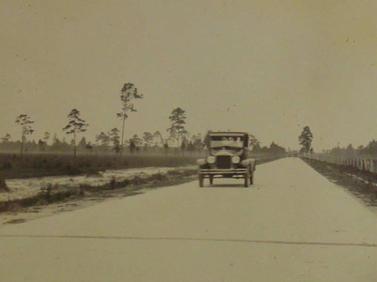 About four or five miles past the White Kitchen was the Mississippi state line and the Pearl River bridge. There was a truck stop, gas station and restaurant with overnight cabins on the left at Pearlington. It was also the Greyhound bus station for Pearlington, Mississippi. The name of this place changed over the years. At one time it was Hendrix’s English Tavern. My Dad’s brother, Rod, worked at Hendrix’s pumping gas when he was a teenager. Later in the 1950s it became the Half Way Inn and operated under several other names over the years. Once you passed through Pearlington, there was about a twenty-mile journey on two-lane Highway 90 into Waveland. There wasn’t much other than the occasional family run filling station-grocery store along the way. I remember that there were a couple of mom and pop places like J. W. Maskew’s Place close to where Highway 90 and Highway 607 split going to Picayune. The Asher family also ran a grocery and gas station out that way. About five miles west of Waveland the landscape changed from cypress and pine swamp to grassy scrub pine acreage. Hwy 90 into Bay St. Louis 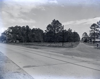 The intersection of Hwy 90 and Main Street The intersection of Hwy 90 and Main Street One needs to understand that at this time the downtown Bay St. Louis business district bordered from Ulman Avenue to Washington Street and Necaise Avenue to Beach Boulevard and that was it. This was the business hot spot. There were no other commercial areas. Back of town by the L&N depot and along Ulman Avenue were both considered to be part of downtown. Highway 90 at the time was just as described earlier, a two-lane highway running through marsh, cypress swamps, grassy scrub pine acreage and cow pastures before arriving in Bay St. Louis. The only businesses on Highway 90 were a few gas stations/truck stops (Batey’s was at Nicholson Avenue-Highway 603, and Phillips 66 truck stop was further west, just before Old Spanish Trail), restaurants, roadhouses, and tourist courts (little individual cabins for rent overnight). Most all of the praline and souvenir shops that would eventually be so prevalent out on the new highway 90 were located in town on old Highway 90, which was Ulman Avenue. Out where Main Street crossed Highway 90, there was a tavern with gasoline pumps named Craddock’s (and later Compretta’s). This was located where the Shell Station currently stands. Farther east, just before DeMontluzin Street, there was a restaurant and tourist court named The Pines on the right where Coast Electric headquarters building eventually would be built. This whole complex would become the Bay St. Louis City Hall and municipal complex that we know today. At the time all this was mostly just scrub pine and grassy woods. There wasn’t much else out there before the highway curved right, became Ulman Avenue and ran on into downtown Bay St. Louis. Hwy 90 Becomes Ulman Avenue This was before the second Highway 90 automobile bridge was opened in 1954. At that time Highway 90 curved in from the west right where Ulman and Carroll Avenue meet at the highway service road. The highway ran down Ulman Avenue past Coach’s Corner Bar on the left (the office of Kergosien Insurance today). This road was lined with restaurants, bars, car dealerships and service stations. There were many, many businesses located on Ulman Avenue at the time. Coach’s Corner Bar, Bertucci’s, Ray’s Drive In (Lil' Ray Kidd’s father), Muller’s Restaurant/Bar and Tourist Court (later also run by Daddy Ray Kidd), Palmisano’s, Katie’s, Cook’s and other candy shops , Uncle Joe’s Drive Inn, Mom’s Restaurant and Ward’s Cafe were just a few of the businesses one passed driving down Ulman to the old wooden bridge. A few of the buildings that housed these businesses are still standing today. There were automobile dealerships like Gilmore Chrysler which later became Monitor Paneling Company (where my Boy Scout leader, Mr. Lavern Pahlman worked). This business stood at the corner of Ulman and Dunbar where the apartments are now located. Ulman Avenue was also home to Adams Loraine Flower Shop (now the location of the second Maison Antique) and at least five or six filling stations run by people like Mr. Bernie Piazza, August Scafide, Leo Taconi and the Starita family. Most all of these gas stations along this route functioned as mechanic shops as well. The Divine Word Missionaries’ St. Augustine Seminary was located on a huge track of land north of Ulman Avenue between Dunbar Avenue and Second Street. The Seminary, as we called it, provided a plethora of adventures to kids like me and my friends over the years (more about this later). Mr. Pete Porter’s Pontiac dealership was further down in the first block just behind the Hotel Reed. The Chevrolet dealership, Gulf Chevrolet, was on South Beach Boulevard at the corner of Court Street. The Bay Ford dealership was located just up Court Street in the building that now houses The Sea Coast Echo newspaper. Grandpa George’s best friend, Ben Hille, owned the Oldsmobile/GMC dealership located down South Beach Boulevard just past Washington right next to The Star Theatre. Mr. Pete Porter’s Pontiac Dealership and Gulf Service Station also served as the Greyhound bus station until it was later relocated back out towards Dunbar Avenue right right next door behind my friend Billy Shumski’s house. 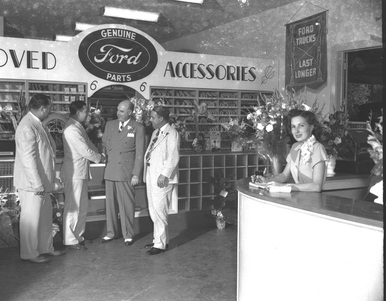 Interior of the Bay Ford Dealership located up Court Street behind the Courthouse in the building that now houses the Sea Coast Echo. The well dressed bald gentlemen shaking hands is Bobby Camors who owned the dealership. (Pat Murphy Archive Interior of the Bay Ford Dealership located up Court Street behind the Courthouse in the building that now houses the Sea Coast Echo. The well dressed bald gentlemen shaking hands is Bobby Camors who owned the dealership. (Pat Murphy Archive Ulman Avenue/Highway 90 intersected with North Beach Boulevard with a red light at the intersection. Continuing east brought you onto the old wooden Highway 90 car bridge over the Bay of St. Louis and eastward to Henderson Point in Pass Christian. I have very early fuzzy memories of this bridge catching on fire a lot. I’ve been told that this was caused by sparks from the old automobiles backfiring and igniting the tar surface of the bridge roadway. This old bridge, which had been built in 1927, ended on what is now Bayview Street on Henderson Point. This entrance to Henderson Point ran right in front of Bennie French’s Tavern, Annie’s Restaurant, Cunningham’s Grocery and several other bars and restaurants. Before this wooden car bridge was constructed in 1927, a ferry boat took automobiles and passengers across the bay to Henderson Point. The ferry dock on the Bay St. Louis side had been located on Beach Boulevard in the vicinity of DeMontluzin Street. The main business district of Bay St. Louis ran along Ulman Avenue to the beach right down Beach Boulevard and really, up Main Street. There were other businesses scattered downtown on Court Street, the depot area, Washington Street or Second Street, but the heaviest concentration of them were located close to the beach. The downtown Bay St. Louis of my youth was a place where the locals could find most anything that they needed to buy. From restaurants, bars and car dealerships to department stores, appliance stores and grocery stores, everything that the shopper needed was right there within a few blocks. On Saturday nights one could go on a date, enjoy a great meal at Manieri’s and then see a movie at The A&G Theatre. Mom could take the kids to Delph’s for school shoes, stop at Bressler’s Café for blue-plate special lunches and end up grocery shopping at Mr. Scharff’s Jitney Jungle. Sometime in between all this, she might have gone into Bufkin’s with the kids to check out those new-fangled color television sets! In this modern day environment of Wally Worlds and regional shopping developments, it’s hard for the average person who didn’t grow up here to realize just how self-contained this area really was. Comments are closed.
|
Categories
All
Archives
July 2024
|
Shoofly Magazine Partners
Our Shoofly Partners are local businesses and organizations who share our mission to enrich community life in Bay St. Louis, Waveland, Diamondhead and Pass Christian. These are limited in number to maximize visibility. Email us now to become a Shoofly Partner!














 RSS Feed


